

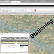
Working for a large civil engineering firm, PLS created a web based Information Management system that imports project “daily” files, related documents etc (indexed by GPS coordinates) into a SQL Server database.
This is used to create “feature layers” in a GIS map (ESRI ARC-SERVER) that can be viewed and queried for progress and all documents related to points along a project. (i.e. a pipeline project)..
Visual Studio, C#, Silverlight, WCF (REST-FUL) Web Services, Entity Framework, SQL Server, ESRI GIS API REST Services for Silverlight.
About Us
 ProLab Solutions (PLS) evolved out of an engineering company “Bremson Data Systems” out of Lenexa KS. Bremson’s main focus was Photo Lab automation. This covered everything from Business and Production Control systems to equipment design and manufacturing.
This included circuit board design, mechanical designs and embedded, desktop and server software systems. Over the years partnered with Kodak on many projects and was eventually bought be them in 1997.
At that time Todd Hamilton formed ProLab Solutions Inc. and, partnering with other ex-Bremson engineers continued working with Kodak and others in the professional imaging industry. Recently our focus has shifted to GIS technology as we work with a large civil engineering company on their GIS needs.
ProLab Solutions (PLS) evolved out of an engineering company “Bremson Data Systems” out of Lenexa KS. Bremson’s main focus was Photo Lab automation. This covered everything from Business and Production Control systems to equipment design and manufacturing.
This included circuit board design, mechanical designs and embedded, desktop and server software systems. Over the years partnered with Kodak on many projects and was eventually bought be them in 1997.
At that time Todd Hamilton formed ProLab Solutions Inc. and, partnering with other ex-Bremson engineers continued working with Kodak and others in the professional imaging industry. Recently our focus has shifted to GIS technology as we work with a large civil engineering company on their GIS needs.