

Storefront Website
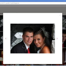
Photographer’s Storefront Website. AngularJS, CSS3 and PHP scripting. Developed for Kodak Alaris, working with a Kodak development team as part of a larger solution for Professional Labs and Photographers.
Civil Engineering GIS Mapping System
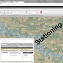
Working for a large civil engineering firm, PLS created a web based Information Management system that imports project “daily” files, related documents etc (indexed by GPS coordinates) into a SQL Server database. This is used to create “feature layers” in a GIS map (ESRI ARC-SERVER) that can be viewed and queried for progress and all documents related to points along a project. (i.e. a pipeline project).. Visual Studio, C#, Silverlight, WCF (REST-FUL) Web Services, Entity Framework, SQL Server, ESRI GIS API REST Services for Silverlight.
GeoAccess (GIS mapping)
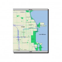
GeoAccess, Inc. is the company that pioneered the use of geographic data to analyze the accessibility of health care networks. Prior to GeoAccess’ work in the early 1990s, the accessibility of health care networks was estimated by comparing zip codes of health care providers and consumers. GeoAccess developed software applications which allowed the accessibility of health care networks to be accurately measured based on the geographic coordinates of health care provider locations. For the first time, employers and government-sponsored programs could establish access standards to take the actual accessibility of health care providers into account when selecting health care networks. By the mid-1990s, GeoAccess-based analysis was the industry standard for measuring the accessibility of health care networks.[1][2] PLS assisted with “Tiger” data processing backend jobs to convert USPS mapping data into SQL Server and compressed DB files for the applications. Wrote the mapping report / overlay rendering engine used in the desktop app & the CGI report request engine. The report request engine used a service to look for report request files (XML) that got dropped into a directory, generated the report files (Images and PDF) & routed them to either a mail server of the file server. Later on we rewrote it to use MSMQ to distributed reporting servers. This was all used by a web based front end to process and email reports to customers. This included mapping, charts etc..included generating distance calculations for these reports based on the scale & overlay of way points (Doctors’ offices). Several people from that team went on to work at...
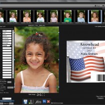
Digital Albums and Books Ordering System
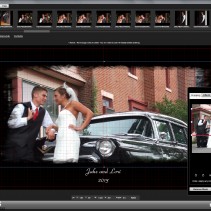
For many years PLS has worked with Miller’s Professional Imaging and their engineers & project managers to develop and support their software needs. Server side services and client side applications including page layout applications for creating wedding albums and other book applications. TCP-IP communications, uploading 100,000 + images everyday. Server side services automatically import jobs to production for printing. www.millerslab.com
Yearbook Ordering System
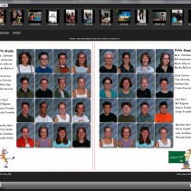
PLS worked with Interstate Studios to develop their yearbook program. This provided automatic and semi-automatic page layout of class pages and full page editing / layout tools. Uploading over TCP-IP to Interstate’s servers. PLS also reworked their production system to convert incoming jobs to CMYK color space and convert the books to PDF format in preparation for final printing. http://www.inter-state.com/
About Us
 ProLab Solutions (PLS) evolved out of an engineering company “Bremson Data Systems” out of Lenexa KS. Bremson’s main focus was Photo Lab automation. This covered everything from Business and Production Control systems to equipment design and manufacturing.
This included circuit board design, mechanical designs and embedded, desktop and server software systems. Over the years partnered with Kodak on many projects and was eventually bought be them in 1997.
At that time Todd Hamilton formed ProLab Solutions Inc. and, partnering with other ex-Bremson engineers continued working with Kodak and others in the professional imaging industry. Recently our focus has shifted to GIS technology as we work with a large civil engineering company on their GIS needs.
ProLab Solutions (PLS) evolved out of an engineering company “Bremson Data Systems” out of Lenexa KS. Bremson’s main focus was Photo Lab automation. This covered everything from Business and Production Control systems to equipment design and manufacturing.
This included circuit board design, mechanical designs and embedded, desktop and server software systems. Over the years partnered with Kodak on many projects and was eventually bought be them in 1997.
At that time Todd Hamilton formed ProLab Solutions Inc. and, partnering with other ex-Bremson engineers continued working with Kodak and others in the professional imaging industry. Recently our focus has shifted to GIS technology as we work with a large civil engineering company on their GIS needs.